Advent Day 16: Quantifying recovery and regeneration
Dec 16, 2025
Disturbance, like the kinds that I’ve been talking about the past couple of days, is only half the story. What happens after fire, harvest, storms, or drought, how forests recover, regenerate and reorganize, shapes ecosystem function into the future. Recovery and succession may involve changes in structure, composition, productivity, and stability. This process often unfolds gradually and unevenly across a landscape. These processes are difficult to observe comprehensively in the field. Good thing for us, these same processes leave clear signatures in remote sensing time series.
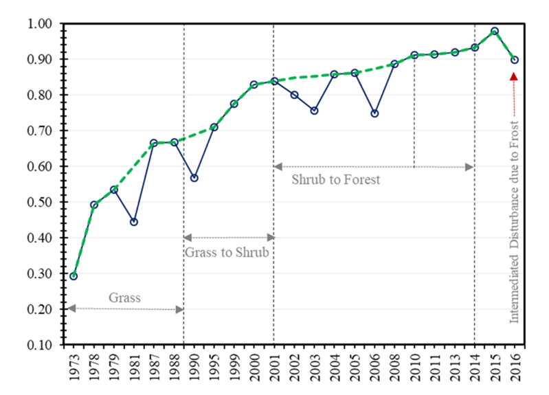
Forest succession is a classic example (and one of my favourites). After a stand-replacing disturbance, early recovery is often marked by rapid increases in greenness and productivity as herbs, shrubs, and pioneer trees establish. As succession gets going and assuming no further disturbance events, as shown in the figure from Abbas et al 2023, remote sensing time series reveal an increase in NDVI through time. Structural recovery follows more slowly, as canopy height, biomass, and vertical complexity increase through time. Remote sensing allows ecologists to separate these processes (spectral recovery does not necessarily mean structural recovery) and to track how different successional pathways emerge under varying climates, soils, and management histories.
Remote sensing approaches commonly used to study recovery and regeneration include:
- Vegetation indices to track post-disturbance greening and productivity gains
- Time series analyses to quantify recovery rates and identify stalled or altered succession
- Structural attributes from lidar or photogrammetry to measure biomass accumulation and vertical complexity
- Spatial patterns of recovery to detect heterogeneity driven by topography, legacies, or disturbance severity
By following recovery through time, ecologists can ask deeper questions than “did the forest return?” Remote sensing reveals how fast ecosystems recover, which pathways they follow, and where recovery diverges from historical trajectories. This is increasingly important in the context of climate change, where regeneration failure, shifts in dominant species, and novel successional states are becoming more common. Tracking recovery and succession with remote sensing data helps ecologists distinguish resilience from transformation, and understand when and the characteristics of ecosystems that are rebuilding, or becoming something new.
–
References
Abbas, S., Nichol, J., Usman, M., Abbas, S., Nichol, J. E., Muhammad Irteza, S., & Usman, M. (2023). Impact of Fire on Secondary Forest Succession in a Sub-Tropical Landscape. Forests., 14(5). https://doi.org/10.3390/f14050865