Advent Day 11: Phenology from above
Dec 11, 2025
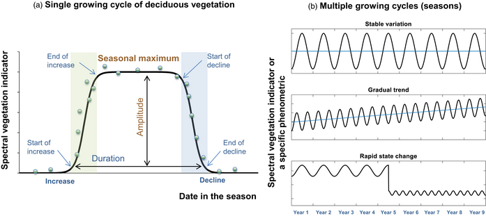
Remote sensing can be used to detect a full suite of phenological metrics such as start-of-season, end-of-season, peak greenness, peak timing, greening rates, senescence rates, growing-season length, the magnitude of seasonal productivity, leaf-out and senescence. And with data across multiple seasons, we can capture inter-annual dynamics. Within and between year phenological metrics are depicted in this image from a review paper by Dronova & Taddeo 2022.
Remote sensing offers the possibility of monitoring phenological patterns consistently across years. Long-running sensors like AVHRR and MODIS provide coarse-resolution, decades-long time series ideal for landscape and regional phenology. Satellites such as Landsat and Sentinel-2 offer higher spatial detail at the cost of shorter records. Airborne campaigns and uncrewed aerial vehicles (UAVs) offer resolution to the plot- or tree-level, but may trade off spatial coverage and temporal continuity across years. Together, these sensors form a multi-scale record of vegetation seasonality, from individual trees to global patterns.
Ecologists use remote sensing derived phenology indicators to study:
- early or late spring leaf-out
- drought-induced early senescence
- shifts in growing season length
- identify climate-sensitive regions
- climate-driven species and functional group differences
- connect phenological changes to life history outcome for wildlife
Phenology metrics are tightly linked to climate. Warmer springs can trigger earlier leaf-out; hotter, drier summers can accelerate browning; delayed autumn cooling can prolong the growing season. In the context of climate change, these shifts are more than timing quirks—they reshape ecosystem function. Changing phenology alters carbon uptake, water use, competitive balances among species, wildfire risk, pollination timing, herbivore foraging windows, and the synchrony between plants and the animals that depend on them. Remote sensing is one of the only tools that can track these changes consistently across landscapes and decades, revealing where ecosystems are adapting, where they’re stressed, and where they may be approaching ecological thresholds. Remote sensing helps address these challenges by turning phenology into a measurable, monitorable indicator of ecosystem response.
–
References
Dronova, I., & Taddeo, S. (2022). Remote sensing of phenology: Towards the comprehensive indicators of plant community dynamics from species to regional scales. Journal of Ecology, 110(7), 1460–1484. https://doi.org/10.1111/1365-2745.13897